A not so widely advertised feature of the Garmin Edge cycling computers is the ability to use free maps from open sources. There are two main reasons why someone would want to this:
- Garmin maps can be very expensive; or,
- to get a map for an area not covered by Garmin maps.
That said, for simple map navigation, these maps are great, free, and totally legit.
Here’s how to do it:
Select and Download the Map Area:
Download and install Mobile Atlas Creator (MobAC). Formerly known as TrekBuddy Atlas Creator, it is an open source (GPL) program which creates offline atlases for GPS handhelds and cell phone applications.
Install it (unzip it) and run it simply by clicking on the Mobile Atlas Creator.exe file (if you plan on using it a lot, just make a shortcut to this file on your Desktop). You’ll be presented with a screen that looks like this:

You can easily change the map area in view by zooming in and out with your mouse wheel. To move to the left and right simply move the mouse with the right mouse button pressed. You’ll note a scale for Zoom level in the upper left hand side of the map screen. Centre the screen on the area you would like to capture.
Under map source in the margin on the left, you’ll see a drop down menu with various open map sources. Older versions of MobAC would let you view non-open-source maps, like those of Microsoft Maps and Google Maps, but these agencies required MobAC to remove these sources, and all that is available now are those maps from OpenStreetMap. This is fine for cycling actually, as I have found the best map for cycling is the OpenStreetMap Cyclemap. It shows off-road bike trails (including MTB trails), as well as elevation contours.
So, under the Map Source drop down menu, select OpenStreetMap Cyclemap. Under Zoom level, check only 14. Higher zoom levels do not work in the Edge devices, and lower zoom levels do not show up with enough detail. Note that unlike Google Maps on your Iphone or Android phone, which looks at distinct tiles on different levels when zooming in and out, Garmin devices let you look at one big picture map, and when you press + and – on the unit to zoom in and out, it just increases or decreases the magnification on that one big map, so it is critical that you use the right zoom level, and only one zoom level.
Now, give your map a name in the Name: box, and click on Add Selection. Your screen should look like this below:

Then, simply click on Create atlas and your file will be created (*.kmz format) in the location specified.
Moving the kmz file to your unit then simply requires that you plug the Garmin unit in with USB cable, and transfer it to the right location, as follows:
Install the Custom Map on your Garmin Edge:
(Note, this procedure applies specifically to the Edge 800, but would be similar for the 705).
1. Plug your unit into your PC via the USB;
2. Open the directory for the SD card (assuming you have one, if you don’t, simply use the existing memory card in the unit, assuming there is enough space on it);
3. Create a directory inside the Garmin directory called CustomMaps (no space), so something like k:\Garmin\CustomMaps;

4. Move the .kmz file into it.
Then, disable the other maps in your Garmin 800
1. Unplug the unit from the PC and turn it on;
2. Go Menu > Settings (wrench icon) > System > Map > Select Information Map;
3. Click on the other maps and select Disable;
4. Click on the Custom Map HK_Territory (or whatever you've called it) and make sure it is Enabled.
That’s it!
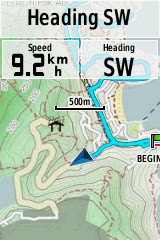
The result should look like this when looking at the map page in the unit. Note the detailed contours and trails, and even the golf course area in grey, around the Discovery Bay district here in Hong Kong: